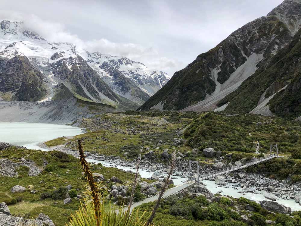
Sadly, the Hooker Valley Track, a popular day walk in Mt Cook, is currently closed after the first bridge. Riverbank erosion has impacted the second bridge and is now deemed unsafe. A new bridge is scheduled to be completed but that will take some time.
Although you can still walk to the Mueller Lake Lookout, you may be wondering what other walks you can do in Mount Cook National Park with equally stunning views.
To help you out, I’ve compiled a list of the best alternative hikes in Mt Cook National Park while the Hooker Valley Track is closed.
» Planning a trip to Mount Cook? Check out our Christchurch to Queenstown road trip itinerary and our guide to the best stops to make when driving from Queenstown to Mt Cook.
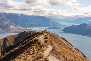
Having been to Mount Cook National Park over half a dozen times, I’ve explored most of the hikes and walking tracks around Mt Cook on numerous occasions. Surrounded by glaciers, pristine lakes and snow-capped mountains, it’s one of my favorite places to visit in New Zealand in any season.
As one of the top attractions in New Zealand, I still think Mount Cook is worth visiting, even if you can’t walk the full Hooker Valley Track.
I’ve included a range of fantastic day walks in Mt Cook, from short easy tracks to a few more challenging hikes so you can easily choose the trails that suit your fitness and interests best.
Grab your hiking boots and get ready to explore the beauty of Mount Cook National Park!
My top 3 Easy Trails in Mt Cook besides the Hooker Valley Track
Combine all 3 for a variety of viewpoints and similar timeframe to the Hooker Valley Track.
Easy Day Walks in Mt Cook
1. Bowen Bush Walk

Time needed: 10 minutes
Difficulty: Easy
Distance: 250 meter loop
Elevation gain: Flat
Starts from: Opposite the petrol pumps
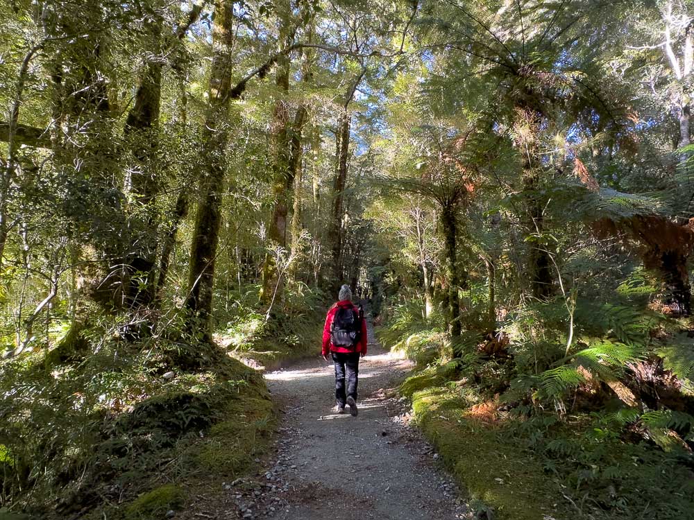
An easy forest walk on a moss covered trail through tōtara and celery pine forest, this 10 minute loop is hardly a hike. However the birdsong was amazing when we visited and it’s a nice walk the whole family can enjoy.
The trail starts just opposite the petrol pumps on Bowen Drive and joins with the Governors Bush Walk for a longer nature walk.
It’s a good option for families or if the weather is bad and you need a little escape from cabin fever.
2. Governors Bush Walk
Time needed: 30 – 60 minutes
Difficulty: Easy
Distance: 1.6 km loop
Elevation gain: 100 meters
Starts from: Behind the Mt Cook Village Public Shelter
The Governor’s Bush Walk is a gentle, family-friendly trail that winds through a lush native beech forest, offering a peaceful contrast to the alpine environment.
This short loop track gently traverses the side of Mt Kitchener through towering trees, ferns, and native birdlife, providing a peaceful and sheltered escape. Ideal if it’s raining or you need to stretch your legs while waiting out gloomy weather.
The walk starts from the Public Shelter on Bowen Drive, where you’ll find a medium sized car park. Or you can park at the visitors centre, which is a 5-minute walk from the Public Shelter.
It’s a lovely nature walk with a gradual incline and only a few steps that leads to a lookout point featuring Wakefield Ridge and Aoraki/Mount Cook. At the highest point there’s a small gap in the forest where you can see the Hooker Valley below.
This walk is a great option for all ages and fitness levels, perfect for a relaxing stroll while enjoying the natural beauty and tranquility of the park.
After descending to the banks of Black Birch Stream, you’ll come to a junction in the track where you can continue the circuit back to the Public Shelter or follow the trail to the Red Tarns Track (details below) for a longer and more challenging walk.
3. Glencoe Walk
Time needed: 30 minutes
Difficulty: Easy
Distance: 1 km return
Elevation gain: 40 meters
Starts from: Directly behind the Hermitage Hotel
The Glencoe Walk is a short trail that zigzags through the forest with a short but steep climb to a bird’s-eye view of Mt Cook village and beyond to the Hooker Glacier and Aoraki/Mount Cook.
Head to the rear parking lot at the Hermitage and look for the start of the trail at the back of the building. The trail is easy to follow and finishes at a park bench near the water tanks above the Hermitage.
It’s a good walk to do if it’s raining thanks to the canopy of trees that provide some cover.
4. Blue Lakes and Tasman Glacier View
Time needed: 20 – 40 minutes
Difficulty: Easy (with some stairs)
Distance: 1.5 km return
Elevation gain: 100 meters
Starts from: Tasman Glacier car park
A relatively easy walk offering stunning views of the Blue Lakes and a peek of the Tasman Glacier. At approximately 22 kilometers long, it’s the longest glacier in New Zealand.
The trailhead starts from the carpark at the end of Tasman Valley Road, about a 10 minute drive from Mount Cook Village. Walk past the Blue Lakes shelter and follow the trail up past the Blue Lakes (which are actually green pools nestled into the valley) to a viewpoint on the moraine wall.
There’s about 100 stairs to climb on a well graded track, but honestly it’s a short climb and the reward outweighs the effort. There’s also plenty of opportunities to stop for photos on the way up.
I especially like this spot for sunset, as the light softens into shades of blue over Tasman Lake.
There’s a spur trail that branches off the Tasman Glacier View Track and takes you to the edge of the Blue Lakes. Personally, I’d give this a miss if you’re short on time. The elevated views are much better.
This is a good option to see elevated views of the Tasman Glacier and Blue Lakes, suitable for all levels.
5. Tasman Lake and River Track

Time needed: 30 – 50 minutes
Difficulty: Easy
Distance: 2.6 km return
Elevation gain: Flat
Starts from: Tasman Glacier car park
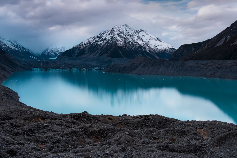
Sunrise at the edge of Tasman Lake is one of my most cherished moments in Aoraki/Mt Cook National Park. Watching the sky turn shades of pink, purple and then blue over the iceberg strewn lake with the snow capped Aoraki/Mt Cook in the distance was a sight to behold.
Even if you don’t make it for sunrise, it’s a great walk to do with breathtaking views.
The Tasman Lake track starts from the same car park as the Blue Lakes and Tasman Glacier View track. These two trails are easy to combine in one outing given they are both short and easy trails, offering different viewpoints.
The trail branches off to the Tasman River and Tasman Lake tracks, offering different perspectives around the lake and further up the river.
It’s a wide, flat path from the parking lot to the Tasman Lake viewpoint, with a short scramble over some large rocks if you want to get close to the edge of the lake. Follow signs for the Tasman River to reach this spot by the lakes edge.
This is a good option for sunrise photography and a chance to get close to icebergs, suitable for all levels.
6. Kea Point Track

Time needed: 60 minutes
Difficulty: Easy
Distance: 3 km return
Elevation gain: 180 meters
Starts from: White Horse Hill Campground car park
The Kea Point Track is a nice and easy walk on a wide gravel path that takes you to the foot of the glacier moraine wall with fantastic views of Mount Sefton, Mueller Glacier Lake and Mt Cook from the viewing deck.
It’s a lovely spot for sunset and you can often hear (and sometimes see) avalanches thundering down the mountain on the other side of the lake.
The trailhead starts from the parking lot at the White Horse Hill Campground or, for a longer walk, you can start from Terrace Road near Aoraki/Mt Cook Visitors Centre. Factor in an additional hour for the longer walk.
The walk begins on the same track as the more challenging Sealy Tarns and Mueller Hut route but veers off to the right.
This is a good option if you are looking for an easy walk with views of the distant glaciers. It’s suitable for all levels and can easily be combined with some of the other short walks.
Best Intermediate Hikes in Mt Cook
7. Red Tarns Track
Time needed: 2 hours
Difficulty: Moderate
Distance: 4 km return
Elevation gain: 325 meters
Starts from: Mt Cook Village Public Shelter on Bowen Drive
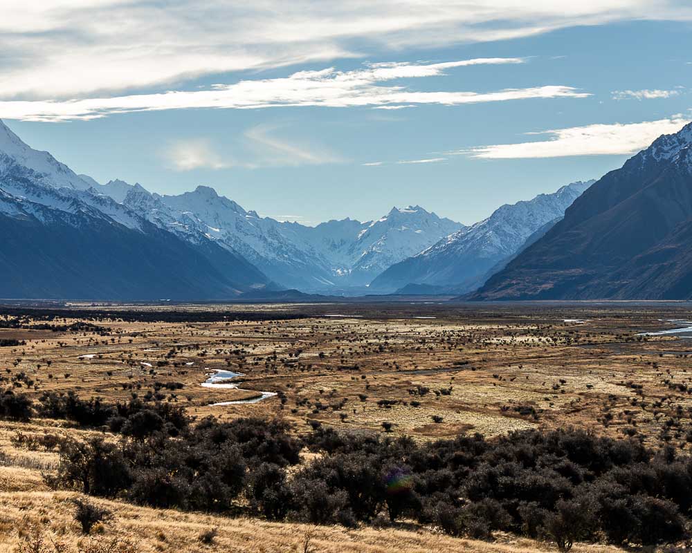
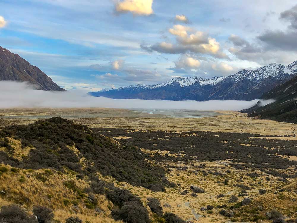
The Red Tarns Track is the most underrated walk in Aoraki/Mt Cook in my opinion. It’s a track you don’t see too much information about, yet offers beautiful panoramic views of the Southern Alps and a birds eye view of the Hooker Valley with its braided rivers and proglacial lakes.
It’s a good one to get away from the crowds, and a beautiful spot for photography. Especially for sunrise or sunset, when on a still day, the mountain tops are reflected in the tarns.
There’s a parking lot at the trailhead on Bowen Drive, or it’s a 5 minute walk from the Aoraki/Mount Cook National Park Visitor Centre. Being less popular than the Hooker Valley Track, we’ve never had an issue getting a park at the trailhead.
While the trail is not technically difficult, it requires moderate fitness. The trail starts off on a wide path (same as the Governors Bush Walk) and ascends into a steep climb for about 1- 1.5 hours with some made-made stairs on a well graded path. There’s a small stream crossing and a few rocky sections to get to the viewpoint and the tarns.
This is a good option to get a birds eye view of the landscapes for less effort and fewer crowds than the Sealy Tarns track.
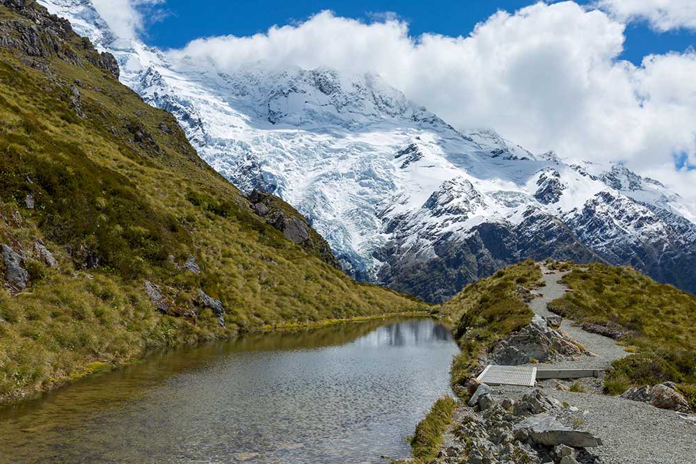
8. Sealy Tarns Track
Time needed: 3 – 4 hours
Difficulty: Moderate
Distance: 5.1 km return
Elevation gain: 600 meters
Starts from: White Horse Hill Campground car park and the Kea Point Track
Ready to tackle 2,200 steps for epic views over the Hooker Valley Track and Aoraki/Mt Cook?
Often referred to as the ‘stairway to heaven’, the Sealy Tarns track is not technically difficult, although it gets steep and narrow near the top, and you’ll definitely feel the burn.
However, it will be worth it. The reward is worth the effort (even though it may not feel like it as you curse me on the way up). And it doesn’t take long to be rewarded, with views of the stunning landscape below unfolding with each step.
The track starts on the Kea Point Track and continues on to the Sealy Tarns track.
Prepare for lots of photo stops, with a birds eye view of Mueller and Hooker Lakes on full display, and braided rivers flowing through the valley floor like an abstract piece of art.
Once you arrive at Sealy Tarns, you’ll get to appreciate the full magnitude of the elevated view over mountain peaks, distant glaciers, and the Hooker Valley below. On a still day, you might even see the mountain tops reflecting in the tarns.
Note – Be sure to check the weather before setting off. Inclement weather can obstruct the views and there can be snow and ice on the track in the colder months.
9. Mueller Hut Route
Time needed: 5-7 hours return (best done as an overnight hike)
Difficulty: Advanced
Distance: 10.4 km return
Elevation gain: 1,052 meters
Starts from: White Horse Hill Campground car park
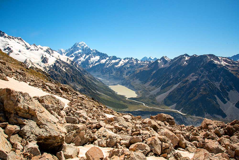
The Mueller Hut Route is considered one of the best hikes in Mount Cook National Park for experienced hikers. A further two-hour hike from Sealy Tarns, this famous red hut was built and opened by Sir Edmund Hilary.
It’s perched in a stunning alpine environment and best done as an overnight hike. You’ll need to book the hut in advance and have a decent level of fitness and alpine experience for this one.
It takes a fair bit of effort and you’ll be rewarded with 360 degree views of the park featuring glaciers, lakes, snow capped mountain peaks and the valley below.
Follow the Kea Point track to the Sealy Tarns track and then continue on the Mueller Hut Route from the tarns.
This is an alpine route with scrub, rock fields, scree and a ridgeline to navigate. Conditions can change quickly. Be sure to check the weather and current track conditions, and register your intent at the Aoraki/Mt Cook Visitor Centre before setting off. Mountaineering experience is needed if snow is present.
Final Thoughts
As you can see, it’s easy to experience Aoraki/Mt Cook National Park regardless of your hiking skill level, even without the Hooker Valley Track. Combining the Kea Point, Tasman Lakes and Tasman Glacier View tracks provides various viewpoints around the park for a similar timeframe and difficulty level that you’d get on the Hooker Valley Track. Regardless of the which trails you choose, you’ll get to experience the beauty of Mount Cook National Park.
YOU MIGHT ALSO LIKE


Travel Planning Guide
🚗 Where should I book my rental car?
Renting a car is one of the best ways to get around New Zealand. Public transportation can only get you so far, even in the cities. I always rent with Discover Cars, which checks the prices of all major rental car companies, so you get the best rates.
🚐 What about a campervan?
Renting a campervan is a fantastic way to experience the more remote areas of New Zealand. I really like JUCY because they have a big range of vehicles and locations around the country, which offers more flexibility with pick-up and drop-off. I also like Motorhome Republic, which compares all the campervan options available in NZ.
🎟 Where should I book my tours?
Tours are a great way to experience New Zealand’s top attractions while learning about the area and culture through local guides. We always use Viator and Get Your Guide to find the best tours.
🛏 What’s the best way to book my accommodations?
For hotels and vacation rentals, Booking.com or Expedia.com are the best sites. You can also book through TripAdvisor. If you’re considering renting a house instead, try VRBO which often has good deals.
🛩 What’s the best site to buy flights to New Zealand?
For finding the best deals on flights to New Zealand from around the world, I recommend Kayak.com.
Like this article? Save it on Pinterest so you can find it again.
FOLLOW US on Pinterest and Facebook for more New Zealand travel inspiration and tips!

Heather is a travel enthusiast living in New Zealand with her family. She writes about living in and enjoying travel to New Zealand.